Like us on Facebook
 
Follow us on Twitter
 
Visiting The Club


All the information contained or linked below is provided for outline guidance only. Condition and routes of the navigable channels often change. Before proceding upstream of the Humber Bridge reference should be made to the current (bi-monthly) chart for the Upper Humber and Notices to Mariners issued by ABP Humber. These are usually available on-line with charts also stocked by Kildale Marine chandlery situated at Hull Marina.

VHF and Telephone
The club uses VHF channel 37 (M1), however this is generally only monitored when races are in progress.
Humber VTS should also be monitored on channel 15 whilst above the Humber Bridge.
     
Brough Clubhouse: 01482 667224  
Winteringham Clubhouse: 01724 733458  
 

General Situation and Outer Mark Locations
 

Brough Haven Entry


The Brough base of Humber Yawl Club is situated on the north bank of the Humber adjacent to the former British Aerospace factory.

Entry is possible approximately 2 hours either side of high water depending on tidal conditions and the draft of vessels.

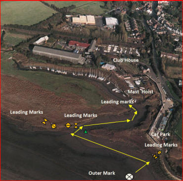
Initial approach is made to the outer mark at approximate position 053d43.4'N, 000d35.05'W (053d43'24"N, 000d35'03"W). Be aware of a strong tidal set and then proceed via leading marks into the creek. Pontoon moorings are situated to starboard. Visiting craft may moor adjacent to the mast hoist in the first instance.

Fore and aft moorings with stern lines may be vacant, but visitors should make enquiries before use.

Brough has a good range of pubs, restaurants, take-aways, shops, a filling station, and railway station with frequent national services.

Photographs showing the deep water path at February 2024 can be found here in the gallery.


Winteringham Haven Entry

Winteringham Haven is situated on the south bank of the Humber, approximately 1.5 miles due south of the HYC base at Brough.

Visitors are advised to contact the Winteringham Club House for up to date advice on the amount of water available at particular states of the tide.

The buoy which marks the entrance to the creek is at approximately 053d42.05'N, 000d34.86'W (053d42'03"N, 000d34'51"W). From the outer mark the channel into Winteringham Haven is marked by a series of red and green cans and can be quite shallow even at Spring tides. The creek is sinuous and bordered by reed beds. Deeper water exists on the outer edges of the bends.

Fore and aft pontoon moorings in the haven are on the starboard hand. Electricity and water points are available.
The club house, toilet and shower facilities are situated towards the head of the creek.

The village of Winteringham is a ten minute walk from the club where there is a pub, a restaurant, a post office and several small shops.

Dylan Winter's video footage of entry to Winteringham Haven: http://www.youtube.com/watch?v=oCWTQYZ7Do0
 

Upper Humber - General
 
In addition to information on the ABP Humber website, Dylan Winter's video footage of the HYC havens and Upper Humber provides an interesting and helpful reference of what to expect when visiting by water. However please be mindful that the condition and route of the channels often change and take note of the latest ABP chart and recent NTMs.

Trent Falls (if approaching from the rivers Trent or Ouse): http://www.youtube.com/watch?v=1v2nqHze-6A
Sailing the tides: http://www.youtube.com/watch?v=IVRdf0seHxY
Humber tides: http://www.youtube.com/watch?v=ELEsYcEwWog
Brough Explained: http://www.youtube.com/watch?v=E-YJovqxPHE
 
   
© Copyright 2024 humberyawlclub.com
Website By Sam Willis